
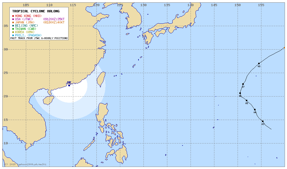
I think the map you show is for a non named regular storm.
The one on the top left. While looking super rainy, you see that there is no designated eye, just a center with two big cloud formation dancing around.
Halong is the storm over the end of the word "Marble" in the bottom middle/middle of the pict. Samller, denser all around the center but without any walled eye yet.
| Hot Topics | |
|---|---|
The Weather Thread.
Re: The Weather Thread.
![]() by Coligny » Thu Jul 31, 2014 8:16 pm
by Coligny » Thu Jul 31, 2014 8:16 pm
You do not have the required permissions to view the files attached to this post.
Marion Marechal nous voila !
Verdun
ni oubli ni pardon
never forgive never forget/ for you illiterate kapitalist pigs

-

Coligny - Posts: 21799
- Images: 10
- Joined: Sat Jan 17, 2009 8:12 pm
- Location: Mostly big mouth and bad ideas...
Re: The Weather Thread.
![]() by wagyl » Thu Jul 31, 2014 8:22 pm
by wagyl » Thu Jul 31, 2014 8:22 pm
It has a name, Nakri. Source: http://severe.worldweather.org/tc/wnp/
-

wagyl - Maezumo
- Posts: 5947
- Images: 0
- Joined: Thu Mar 17, 2011 11:08 pm
- Location: The Great Plain of the Fourth Instance
Re: The Weather Thread.
![]() by wagyl » Thu Jul 31, 2014 8:29 pm
by wagyl » Thu Jul 31, 2014 8:29 pm
Meanwhile, I can attest that while this site is great for Europe and North America, it doesn't know shit about Japan. http://www.blitzortung.org/Webpages/ind ... &page_0=41
-
wagyl - Maezumo
- Posts: 5947
- Images: 0
- Joined: Thu Mar 17, 2011 11:08 pm
- Location: The Great Plain of the Fourth Instance
Re: The Weather Thread.
![]() by Mike Oxlong » Thu Jul 31, 2014 8:42 pm
by Mike Oxlong » Thu Jul 31, 2014 8:42 pm
The eye is definitely less defined than when I looked a few hours ago...

•I prefer liberty with danger to peace with slavery.•
-

Mike Oxlong - Posts: 6818
- Joined: Wed Oct 20, 2004 5:47 pm
- Location: 古き良き日本
Re: The Weather Thread.
![]() by Coligny » Thu Jul 31, 2014 9:43 pm
by Coligny » Thu Jul 31, 2014 9:43 pm
Whatch out for the bottom red blob... That's the nasty one...
You do not have the required permissions to view the files attached to this post.
Marion Marechal nous voila !
Verdun
ni oubli ni pardon
never forgive never forget/ for you illiterate kapitalist pigs
-
Coligny - Posts: 21799
- Images: 10
- Joined: Sat Jan 17, 2009 8:12 pm
- Location: Mostly big mouth and bad ideas...
Re: The Weather Thread.
![]() by yanpa » Sun Aug 03, 2014 7:41 am
by yanpa » Sun Aug 03, 2014 7:41 am
This "atsui" phenomenon is still hanging around...
-

yanpa - Posts: 5671
- Images: 11
- Joined: Sun Nov 04, 2007 11:50 am
- Location: Tokyo
Re: The Weather Thread.
![]() by Coligny » Sun Aug 03, 2014 9:08 am
by Coligny » Sun Aug 03, 2014 9:08 am
Dun't worry, rain on the way...
Marion Marechal nous voila !
Verdun
ni oubli ni pardon
never forgive never forget/ for you illiterate kapitalist pigs
-
Coligny - Posts: 21799
- Images: 10
- Joined: Sat Jan 17, 2009 8:12 pm
- Location: Mostly big mouth and bad ideas...
Re: The Weather Thread.
![]() by Coligny » Mon Aug 04, 2014 9:29 am
by Coligny » Mon Aug 04, 2014 9:29 am
Marion Marechal nous voila !
Verdun
ni oubli ni pardon
never forgive never forget/ for you illiterate kapitalist pigs
-
Coligny - Posts: 21799
- Images: 10
- Joined: Sat Jan 17, 2009 8:12 pm
- Location: Mostly big mouth and bad ideas...
Re: The Weather Thread.
![]() by Mike Oxlong » Mon Aug 04, 2014 12:31 pm
by Mike Oxlong » Mon Aug 04, 2014 12:31 pm
Debate of Tropical Cyclone Versus Monsoon Low
The debate over whether the cyclone impacting southern Japan with strong winds and torrential rainfall has been ongoing much of this week.
The Japan Meteorological Agency (JMA) and Philippines Weather Service both named the cyclone a tropical depression earlier this week with the JMA eventually strengthening the cyclone into a Severe Tropical Storm with sustained winds over 60 mph.
This analysis is backed up by torrential rain that fell across the Ryukyu Islands along with wind gusts over 65 mph across Okinawa Thursday into Friday.
Naze, Japan, just north of Okinawa in the Ryukyu Islands, has reported more than 300 mm (12 inches) of rain as the cyclone drifted northward across the area.
A widespread 50-100 mm (2-4 inches) has been reported across southwest Japan with locally higher amounts, and more rain is expected into the weekend across both southern Japan and South Korea.
Meanwhile, the Joint Typhoon Warning Center, while acknowledging the cyclone and issuing high chances for development, ultimately decided not to name this cyclone, instead calling it a monsoonal low because of the broad low pressure without a uniform wind field.
While the debate could go on endlessly over whether this cyclone was indeed a tropical feature or a monsoonal low, the bigger issue is making sure people are aware of the impacts which have included very strong winds and torrential rainfall...
http://www.accuweather.com/en/weather-b ... w/31439615

•I prefer liberty with danger to peace with slavery.•
-
Mike Oxlong - Posts: 6818
- Joined: Wed Oct 20, 2004 5:47 pm
- Location: 古き良き日本
Re: The Weather Thread.
![]() by Coligny » Tue Aug 05, 2014 10:05 am
by Coligny » Tue Aug 05, 2014 10:05 am
Halong got kicked hard in the nuts overnight. Despite still being in hot seawater, it lost its eye, seems to be centrifugating away huge cloud mass (does it even work like that ?) and was downgraded to a cat 2...
Marion Marechal nous voila !
Verdun
ni oubli ni pardon
never forgive never forget/ for you illiterate kapitalist pigs
-
Coligny - Posts: 21799
- Images: 10
- Joined: Sat Jan 17, 2009 8:12 pm
- Location: Mostly big mouth and bad ideas...
Re: The Weather Thread.
![]() by Mike Oxlong » Tue Aug 05, 2014 12:56 pm
by Mike Oxlong » Tue Aug 05, 2014 12:56 pm
Some disagreement over the track, too.
•I prefer liberty with danger to peace with slavery.•
-
Mike Oxlong - Posts: 6818
- Joined: Wed Oct 20, 2004 5:47 pm
- Location: 古き良き日本
Re: The Weather Thread.
![]() by Russell » Tue Aug 05, 2014 8:51 pm
by Russell » Tue Aug 05, 2014 8:51 pm
Mike Oxlong wrote:Some disagreement over the track, too.
Which amounts to "who has the biggest supercomputer?"
I seem to remember that is the Mericans.
But in that case it will pass very near to me. Ouch.
“To learn who rules over you, simply find out who you are not allowed to criticize.”
“I know not with what weapons World War III will be fought, but World War IV will be fought with sticks and stones.” ― Albert Einstein
-
Russell - Maezumo
- Posts: 8578
- Images: 1
- Joined: Fri Aug 13, 2010 11:51 pm
Re: The Weather Thread.
![]() by dimwit » Tue Aug 05, 2014 11:09 pm
by dimwit » Tue Aug 05, 2014 11:09 pm
Gee we are getting more rain tonight. We haven't had that in a while.
-

dimwit - Maezumo
- Posts: 3827
- Images: 3
- Joined: Tue Jun 01, 2004 11:29 pm
Re: The Weather Thread.
![]() by yanpa » Wed Aug 06, 2014 9:09 pm
by yanpa » Wed Aug 06, 2014 9:09 pm
Ooh, it's going to be sunny tomorrow for a change.
-
yanpa - Posts: 5671
- Images: 11
- Joined: Sun Nov 04, 2007 11:50 am
- Location: Tokyo
Re: The Weather Thread.
![]() by dimwit » Thu Aug 07, 2014 12:54 am
by dimwit » Thu Aug 07, 2014 12:54 am
yanpa wrote:Ooh, it's going to be sunny tomorrow for a change.
Hey, I'm definitely not complaining. It has kept the temperature here down below 30 degrees for the last 6 days which for Matsuyama must be pretty close to a record for August.
-
dimwit - Maezumo
- Posts: 3827
- Images: 3
- Joined: Tue Jun 01, 2004 11:29 pm
Re: The Weather Thread.
![]() by Samurai_Jerk » Thu Aug 07, 2014 8:46 am
by Samurai_Jerk » Thu Aug 07, 2014 8:46 am
Meanwhile Tokyo has been hot as fuck.
Faith is believing what you know ain't so. -- Mark Twain
-

Samurai_Jerk - Maezumo
- Posts: 14387
- Joined: Mon Feb 09, 2004 7:11 am
- Location: Tokyo
Re: The Weather Thread.
![]() by yanpa » Thu Aug 07, 2014 8:59 am
by yanpa » Thu Aug 07, 2014 8:59 am
Really? Do tell. I hear it's been atsui as well.
-
yanpa - Posts: 5671
- Images: 11
- Joined: Sun Nov 04, 2007 11:50 am
- Location: Tokyo
Re: The Weather Thread.
![]() by Samurai_Jerk » Thu Aug 07, 2014 9:38 am
by Samurai_Jerk » Thu Aug 07, 2014 9:38 am
yanpa wrote:Really? Do tell. I hear it's been atsui as well.
Yes, but it's not usually the atsuiest place in Japan.
-
Samurai_Jerk - Maezumo
- Posts: 14387
- Joined: Mon Feb 09, 2004 7:11 am
- Location: Tokyo
Re: The Weather Thread.
![]() by Coligny » Thu Aug 07, 2014 9:43 am
by Coligny » Thu Aug 07, 2014 9:43 am
Candies sticking to the wrapper here 
Marion Marechal nous voila !
Verdun
ni oubli ni pardon
never forgive never forget/ for you illiterate kapitalist pigs
-
Coligny - Posts: 21799
- Images: 10
- Joined: Sat Jan 17, 2009 8:12 pm
- Location: Mostly big mouth and bad ideas...
Re: The Weather Thread.
![]() by Yokohammer » Thu Aug 07, 2014 11:26 am
by Yokohammer » Thu Aug 07, 2014 11:26 am
I guess it really depends on whether it's 暑い、熱い、or possibly even 厚い。
-
Yokohammer - Posts: 5090
- Joined: Tue Sep 30, 2008 6:41 pm
- Location: South of Sendai
Re: The Weather Thread.
![]() by Samurai_Jerk » Thu Aug 07, 2014 11:59 am
by Samurai_Jerk » Thu Aug 07, 2014 11:59 am
Yokohammer wrote:I guess it really depends on whether it's 暑い、熱い、or possibly even 厚い。
That reminds me of my first Japanese teacher. When we learned "hot" and "cold" she told us that there are different words in Japanese for cold to the touch ("tsumetai") and cold weather ("samui") but that it was the same word for hot ("atsui"). I didn't realize that the kanji were different depending on which meaning of "hot" you were talking about till years later.
-
Samurai_Jerk - Maezumo
- Posts: 14387
- Joined: Mon Feb 09, 2004 7:11 am
- Location: Tokyo
Re: The Weather Thread.
![]() by Wage Slave » Sat Aug 09, 2014 5:46 pm
by Wage Slave » Sat Aug 09, 2014 5:46 pm
Serious amounts of rain here today and no sign of a let up. It's been raining solidly for a good 12 hours now and the forecast is for another 12 at least. Lots of flood warnings and quite a few people were told to evacuate their homes this morning. High tide is just approaching so there are no doubt some very worried people.
It is a tale told by an idiot, full of sound and fury, signifying nothing.
- Macbeth (Act 5, Scene 5)
William Shakespeare, April 1564 - May 3rd 1616
- Macbeth (Act 5, Scene 5)
William Shakespeare, April 1564 - May 3rd 1616
-

Wage Slave - Maezumo
- Posts: 3765
- Joined: Wed Aug 15, 2012 12:40 am
Re: The Weather Thread.
![]() by dimwit » Sat Aug 09, 2014 8:02 pm
by dimwit » Sat Aug 09, 2014 8:02 pm
It is amazing to me how cavalier some people seem to be around here when a typhoon hits. I know Matsuyama doesn't really get that many but today I have witnessed a construction crane moving heavy steel girders which I am pretty sure either is or should be illegal during high winds, a bunch of demolition workers doing whatever on the roof of a building, and people constructing scaffolding.
-
dimwit - Maezumo
- Posts: 3827
- Images: 3
- Joined: Tue Jun 01, 2004 11:29 pm
Re: The Weather Thread.
![]() by Coligny » Sat Aug 09, 2014 9:22 pm
by Coligny » Sat Aug 09, 2014 9:22 pm
Come on... Expecting a "better safe than sorry" behavior in Japan... Unpossible...
Marion Marechal nous voila !
Verdun
ni oubli ni pardon
never forgive never forget/ for you illiterate kapitalist pigs
-
Coligny - Posts: 21799
- Images: 10
- Joined: Sat Jan 17, 2009 8:12 pm
- Location: Mostly big mouth and bad ideas...
Re: The Weather Thread.
![]() by Mike Oxlong » Sat Aug 09, 2014 9:45 pm
by Mike Oxlong » Sat Aug 09, 2014 9:45 pm
安全第一
•I prefer liberty with danger to peace with slavery.•
-
Mike Oxlong - Posts: 6818
- Joined: Wed Oct 20, 2004 5:47 pm
- Location: 古き良き日本
Re: The Weather Thread.
![]() by Coligny » Sat Aug 09, 2014 11:26 pm
by Coligny » Sat Aug 09, 2014 11:26 pm
And Halong is now officially a tropical storm...
Marion Marechal nous voila !
Verdun
ni oubli ni pardon
never forgive never forget/ for you illiterate kapitalist pigs
-
Coligny - Posts: 21799
- Images: 10
- Joined: Sat Jan 17, 2009 8:12 pm
- Location: Mostly big mouth and bad ideas...
-
yanpa - Posts: 5671
- Images: 11
- Joined: Sun Nov 04, 2007 11:50 am
- Location: Tokyo
Re: The Weather Thread.
![]() by Coligny » Sun Aug 10, 2014 8:43 am
by Coligny » Sun Aug 10, 2014 8:43 am
yanpa wrote:Is "Halong" Typhoon 11?
Raining here.
Yup, next up is Genevieve, everyone's favorite bible thumping aunt...
Marion Marechal nous voila !
Verdun
ni oubli ni pardon
never forgive never forget/ for you illiterate kapitalist pigs
-
Coligny - Posts: 21799
- Images: 10
- Joined: Sat Jan 17, 2009 8:12 pm
- Location: Mostly big mouth and bad ideas...
Re: The Weather Thread.
![]() by yanpa » Sun Aug 10, 2014 9:46 am
by yanpa » Sun Aug 10, 2014 9:46 am
Loudspeakers from the neighbouring commune have just announced 大雨警報. I trust the clouds will continue to respect administrative boundaries.
-
yanpa - Posts: 5671
- Images: 11
- Joined: Sun Nov 04, 2007 11:50 am
- Location: Tokyo
Re: The Weather Thread.
![]() by wagyl » Sun Aug 10, 2014 10:05 am
by wagyl » Sun Aug 10, 2014 10:05 am
Indeed. A benefit of being in the 23 wards - it's more than just a 03 landline number! http://www.jma.go.jp/jp/warn/319_table.html
-
wagyl - Maezumo
- Posts: 5947
- Images: 0
- Joined: Thu Mar 17, 2011 11:08 pm
- Location: The Great Plain of the Fourth Instance
Who is online
Users browsing this forum: No registered users and 56 guests